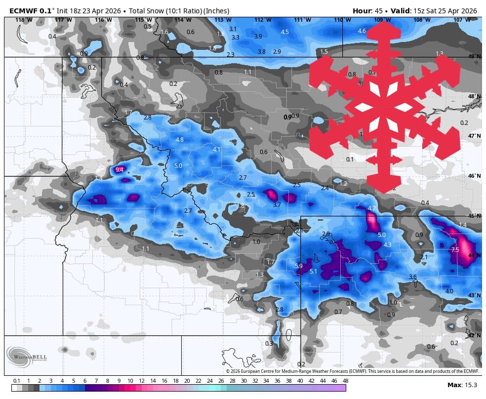
According to the latest meteorological guidance from WeatherBell as reported by SnowBrains, the Northern Rockies are experiencing a targeted period of cold, showery weather. The system, which began earlier this week, is expected to focus the bulk of its moisture on the Teton Range and southwest Montana through the morning of Saturday, April 25.
Confidence in this forecast remains high through Saturday, as weather models show strong alignment regarding the timing and location of the storm. While the Tetons prepare for several inches of accumulation, Idaho resorts such as Bogus Basin and Tamarack are expected to see minimal impacts, with light showers and cold mornings forecasted for the region.
Storm Dynamics and Snow Quality
The current storm is driven by a main snow band moving through the region. Snow levels are descending from an initial range of 4,000–6,000 feet down to near or below resort base elevations overnight. This drop is critical for preserving snow quality at higher elevations, with Snow-to-Liquid Ratios (SLRs) starting between 9:1 and 12:1 before shifting to a lighter 12:1 to 15:1 ratio by Friday morning.
Skiers and riders should be aware of gusty conditions. Northwest winds are predicted to reach 30–45 mph on exposed ridges, likely resulting in wind-affected surfaces across higher terrain.
Expected Resort Snow Totals (April 23 – April 25)
- Grand Targhee: 7–9 inches
- Jackson Hole: 5–7 inches
- Big Sky: 5–6 inches
- Bridger Bowl: 2–3 inches
- Whitefish Mountain: 2 inches
- Brundage: 1 inch
- Tamarack: 0–1 inch
- Sun Valley, Schweitzer, Bogus Basin: 0 inches
Looking Toward Next Week


Following the departure of this system, Saturday is expected to be cold and quiet. While lingering instability may produce scattered, light showers into Sunday and Monday, the potential for a widespread reload of snow is low. Beyond Tuesday, the long-term trend shifts toward warmer, disorganized weather. Models diverge significantly regarding the latter half of next week, suggesting that any further precipitation will likely be light and speculative, with snow levels rising as the period progresses.